Tuesday, July 28, 2009

South Cody Rd. Sub-Division Development. Part 3

Sim Date -04.24.298
Population - 385,540

With the Improvements done to South Cody Rd.- Subdivision, it's time to see
how much growth and new construction it will generate.

10.11.297 Photo # 1753

10.18.297 Photo #1796

10.23.297 Photo #1814

11.10.297 Photo #1861

11.19.297 Photo #1887

11.28.297 Photo #1920

01.18.298 Photo #2039

01.27.298 Photo #2067

04.11.298 Photo #2225

Well, Not as much growth as I had hope to see, but there may still be more to
come.


I'm not sure what my next project will be? The traffic problem is in Airport
City
(corner of Norman rd and Airport City Rd), same old, same
old. I'm not sure what if anything to do about it?

Thanks for stopping by and I'll see you real soon, Louie

Sunday, July 26, 2009

South Cody Rd. Sub-Division Development. Part 2

Date: 09.23.297

Development Plan For S. Cody Rd-SD

Step 1. Demolish Abandon Buildings and unattached Bus Stop.

Photo #9702A


Photo #9765A

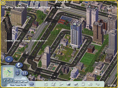
Step 2. Remove Commercial Zone on East Loop.

Photo #9765B


Photo #9903B

Step 3. Demolish Playground #2 (Canceled)

Since discovering Park #2 I have decided to skip step 3 and not to
demolish Playground #2, at least not for now.

I also will plant trees in the void left after de-zoning the Commercial Zone on East Loop.

Photo #9993C


Step 4. Place Pedestrian Mall from Bus Stop #3,
on East Loop to a New Bus Stop on West Loop.

Photo #0062D


Photo #0103D

Photo #0125D

Photo #0154D

Photo #0214D

Photo #0425D

Step 5. Change zones on West Loop, to High Density Residential.

Photo #9702E

Step 6. Re-zone Residential Zones on S. Cody Rd-SD Entrance
to Medium Commercial.

Photo #1225F

Photo #1390F

I decided to add a Medical Station to the 2 empty tiles on the North
Loop.

Photo #0666G


That completes the improvements to S. Cody Rd-SD,
(Both Photos North Views).

Photo #1645


Photo #1699

I should have the result of these improvements posted by Late Tuesday or
Early Wednesday.


Thanks for visiting and Please click my sponsors, Louie

Saturday, July 25, 2009

South Cody Rd. Sub-Division Development. Part 1

Sim Date - 09.23.297
Population - 383,694

South Cody Rd. Sub-Division (S. Cody Rd-SD)

With my improvements done on Airport City I am going to shift my focus
on growth and improvements in the S. Cody Rd-SD.

Here are current photos and a Traffic Map of the S. Cody Rd-SD Neighborhood.

Photo 0607 North View

Photo 1253 East View

Photo 1319 South View

Photo 1352 West View

Triffic Photo 1001

S. Cody Rd-SD Entrance
886 car traffic
617 bus traffic

S. Cody Rd-SD Loop North
782 car traffic
252 bus traffic

S. Cody Rd-SD Loop East
824 car traffic
283 bus traffic

S. Cody Rd-SD Loop South
813 car traffic
88 bus traffic

S. Cody Rd-SD Loop West
175 car traffic
88 bus traffic

Bus Stops Photo 0670A

Bus Stop #1
628 passenger usage

Bus Stop #2
11 passenger usage

Bus Stop #3
417 passenger usage

Bus Stop #4 (View Obstructed)
216 passenger usage

There is also an unattached Bus Stop that will soon be demolished.

There isn't much of a traffic problem in SCR-SD, but as you can see in
Headlines in Photo 1001 there is big time problems somewhere? That will
be something I may have to address soon.

There is also;

S. Cody Rd-SD Library
Funding $122
Book Out 856
Book in Collection 14699

2 Medium Play Grounds

2 Tennis Courts

1 Basketball Court (View Obstructed)

1 Medium Park

2 Unused tiles on North Loop

1 Abandon Building

1 Abandon House (View Obstructed)

Photo 0670B


Development Plan For S. Cory Rd-SD

Objective;

To
stimulate growth in S. Cory Rd-SD, basically by place a Pedestrian Mall centrally
located in the Sub-Division.


Plan;

Step 1. Demolish Abandon Buildings and unattached Bus Stop.

Step 2. Remove Commercial Zone on East Loop.

Step 3. Demolish Playground #2 (Photo 1319A)

Step 4. Place Pedestrian Mall from Bus Stop #3, East Loop to a New Bus Stop on West Loop. (Mark on photo is slightly out of place)

Step 5. Change Medium Density Residential zones on West Loop, to High Density Residential.

Step 6. Re-zone Residential Zones on S. Cody Rd-SD Entrance to Medium Commercial. (Demolish Bus Stop #4 and make new Commercial zone 3 tiles wide or turn zones around and to face Cody Rd.) (Photo 1319B)

Photo 1319A

Photo 1319B

The 2 Unused tiles will be developed but I'm undecided as to what?

I may place Commercial zones on the east side of East Loop and do
something with the south side of South Loop?

Photo 1352


There is also a park or playground I didn't notice on the East Loop, I'm not
sure what to do with it?

I hope to have improvement done and posted by Sunday Night (July26)

Thanks for visiting and Please click my sponsors, Louie

Thursday, July 16, 2009

Airport City Traffic Improvements - part 3

Sim Date -04.05.297
Population - 383,694

Region Population - 598,488

With the traffic improvements in the Airport City Neighborhood done and
seeming to work well.

There is also a few Zone changes on 17th St. and a new Bus Stop
and Park on Airport City Loop East.

West View, Before New Bus Stop and Park. Sim Date -03.07.297 Photo 2606


West View, After New Bus Stop and Park. Sim Date -03.07.297 Photo 2699

The two previous photos also show the Zones on 17th St. Before they were
change to all commercial.

The next photo show a Wider View (North) of Airport City and the old
Zones on 17th St. Sim Date -03.07.297. It is also a nice look at Airport
City
before the road improvements. Photo 0382


View (West) of the New Commercial Zones on 17th St. Photo 2961

Here is a wider View (West) of the New Zones on 17th. Sim Date
-03.17.297. Photo 3076

Another Wide View (North) Date -03.28.297. Photo 3029

The previous photos also show Airport City before any new growth from
the traffic and zoning improvements.


Photos of the New Growth in and around Airport City.

Photo 3113 - Sim Date -04.05.297 - South View

Photo 3147 - Sim Date -04.11.297 - South View

Photo 3224 - Sim Date -05.14.297 - South View

Photo 3340 - Sim Date -06.17.297 - South View


Here is Airport City Before and After Improvements.

Photo 0382 Before Sim Date -03.07.297 North View.

Photo 3718 After Sim Date -09.10.297 North View.

Well that seemed to work out nice.

Next I think I'll work on the Cody Rd Subdivision. It's just west of
Airport City and has been in decline since Main St and 16th St. were widened.

I'll try to post more often but it takes a bit to put these post together.

Thanks for visiting and Please click my sponsors, Louie

Sunday, July 12, 2009

Airport City Traffic Improvements - part 2

Sim Date -03.07.297
Population - 382,396

In an attempt to improve traffic and Development in the Airport City Neighborhood. I needed to do some major changes to Norman rd..

I started with Demolitions on the South end of Norman Rd.

Photo With Buildings soon to be Demolished, (Photo Facing West).

Photo after Buildings were Demolished, (Photo Facing West).

Photo of South End of Norman Rd. with New Pedestrian Mall, Tennis Court and Parks.


(Photo Above)
I discovered that I had a Busing problem and had to replace Two New Parks on each side of the South end of the new Pedestrian Mall.

West Bus Stop
1707 passenger usage
1000 passenger capacity

East Bus Stop
2665 passenger usage
1000 passenger capacity

Two New Bus Stops in Photo Below (Photo Facing East, Other photos Facing West).


Now the work on the North End of Norman Rd. I only had one building to Demolish.

Photo With Building soon to be Demolished, (Photo Facing East).


Photo after building Demolished, (Photo Facing East).


Photo of North End of Norman Rd. with New Pedestrian Mall and a New Park. (Photo Facing East).


Here is the Old Map of Airport City before the new traffic improvements.


Now the New Map of Airport City.


In the Photos notice the dramatic drop in Car Traffic. From 2941 Cars to 648 Cars Just north of the corner of Norman rd. and Airport City Rd.

That seem to have fixed the traffic problems in Airport City for now.

Thanks for stopping by and please check my sponsors, Louie